About three years ago I created a simple map using OpenLayers to display a base layer and overlay some layers on it. It features layers useful to some GB mappers. From the logs I can see that it is used quite a lot. All of the slippy maps I've created recently have used Leaflet rather than OpenLayers so I thought I should update my comparison map in Leaflet. You can see the result here.
It has base layers of MapQuest open, the Standard OSM layer or MapQuest roads. For overlays you can choose from the ITO World tiles of OS OpenData Locator anomalies, the OS OpenData StreetView or my tiles showing the Office of National Statistics postcode centroids. Whichever of the overlays are shown you can move the slider (top-left) to change the opacity to make the base or overlay readable.
The browser address line shows the constantly-updated location and zoom, in the new style of the OSM landing page. This makes bookmarking the position easy. There is also a lat / lon display bottom right which shows you the location the mouse is currently pointing at.
I intend to leave the existing oscompare unchanged and maintain this new leaflet-based one in the future. If anyone would like any other layers or if there is any problem please comment.
Thanks to MapQuest and ITO World for their map tiles and their processes for updating them, thanks to Ordnance Survey for their OpenData and thanks to the OSM admins who manage the OS StreetView tiles.
Sunday, 11 August 2013


Tuesday, 9 July 2013
Locating bridges
I haven't been able to get out mapping much recently, but a lovely day tempted me out. I did some OS Locator name chasing and as is often the case, the OS Locator names led me to a development with far more changes than just the ones OS Locator picks up. I will need to return again as the development grows in Kingswood. There's lots of area obviously earmarked for development but presumably waiting for the cash generated from selling the current houses to fund the next stage.
I then went to look at a newly opened crossing of the river Hull, Scale Lane bridge. It is a pedestrian and cycle route across the river very close to the museum quarter. It lead directly to a large fairly new hotel and towards The Deep, Hull's aquarium, or Submarium as they call it. If you are in the city take a look at The Deep, it is interesting. You walk slowly down to see lower and lower levels in the aquarium and then a glass lift carries you from the bottom back to the top to looking out at the large aquarium as you go.
The new bridge is interesting too. If it opens for river traffic, gates shut at the east end and this end swings around to open for boats, but anyone on the bridge can stay on and people can still get on and off the bridge at the west end. In the middle of the bridge is a building which will be a café eventually and a small exhibition space too I think. These is a sloped cycleway and a flatter footway, except the footway has steps along it. All along the footway there are seats with views looking across the river. It didn't swing open while I was there, but it still looks quite different for a bridge and I like it.
I then took a look at a new development close to home. The Bridgehead development is close to the north end of the Humber bridge. It looks like it will be the usual for commercial buildings: steel structured, clad with glass and shuttering. The first two buildings are under way with room for a few more. The roads are accessible so I grabbed a trace. It is interesting that cycle lanes are being included in the road layouts, since the entrance is off the A15 dual carriageway where there are no cycle lanes. Maybe a new cycleway will join up from the development to the existing cycle lanes nearer the bridge and beyond.
I then went to look at a newly opened crossing of the river Hull, Scale Lane bridge. It is a pedestrian and cycle route across the river very close to the museum quarter. It lead directly to a large fairly new hotel and towards The Deep, Hull's aquarium, or Submarium as they call it. If you are in the city take a look at The Deep, it is interesting. You walk slowly down to see lower and lower levels in the aquarium and then a glass lift carries you from the bottom back to the top to looking out at the large aquarium as you go.
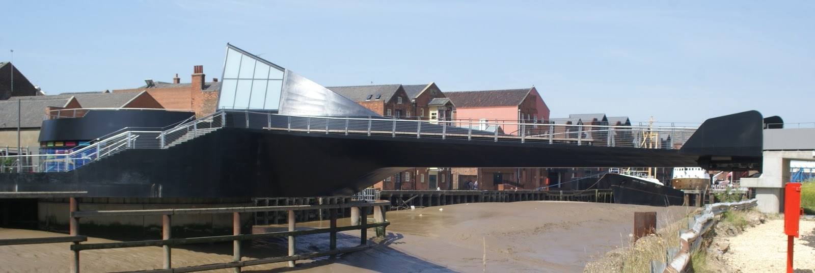 |
| Scale Lane Bridge, the black part swings |
 |
| The Arctic Corsair trawler, now a museum, beside the river Hull walkway |
 |
| The main road crossing of the river Hull and beyond the tidal barrier |
I then took a look at a new development close to home. The Bridgehead development is close to the north end of the Humber bridge. It looks like it will be the usual for commercial buildings: steel structured, clad with glass and shuttering. The first two buildings are under way with room for a few more. The roads are accessible so I grabbed a trace. It is interesting that cycle lanes are being included in the road layouts, since the entrance is off the A15 dual carriageway where there are no cycle lanes. Maybe a new cycleway will join up from the development to the existing cycle lanes nearer the bridge and beyond.
Wednesday, 3 July 2013
OS Locator chasing
I finally got around to sorting out some new OS Locator anomalies close to home. I went to look at a new small road under the shadow of the Humber bridge. When I got there the road was dug up for pipe laying. The tarmac has been down less than 3 months and already the utilities are digging it up again. As I was standing looking down the road, wondering if I should brave the excavators, a woman in a hard hat and fluorescent jacket approached me smiling. She asked if I was interested in the new houses, which are not finished. When I explained I was making a map the smile faded but she agreed I could walk to the end of the road with my GPS 'at my own risk'. Since everything I do tends to be at my own risk I collected my trace. On the way out I asked the once more smiling woman what the road name is going to be and she confirmed the same name that OS Locator has.
Next I went to Welton. Here a slightly bigger development has been squeezed into what was a farmyard many years ago. Here too the road was uneven, but only because the final surface has not been laid. None of the houses looked finished, indeed some were barely started. Here too I was approached by a florescent jacket, this time draped around a young man with a clipboard. He too wanted to sell me a house, but when he heard that I was making a map he asked me to leave as it was still a building site and not safe for the public. As I already had my trace I left, this time snapping a picture of the new road's name board - about the only part of the development that was complete.
I am used to roads showing up in OS Locator as they are close to complete, so seeing ones so obviously early in their development is a little different. Maybe OS are trying to get ahead of the game.
Next I went to Welton. Here a slightly bigger development has been squeezed into what was a farmyard many years ago. Here too the road was uneven, but only because the final surface has not been laid. None of the houses looked finished, indeed some were barely started. Here too I was approached by a florescent jacket, this time draped around a young man with a clipboard. He too wanted to sell me a house, but when he heard that I was making a map he asked me to leave as it was still a building site and not safe for the public. As I already had my trace I left, this time snapping a picture of the new road's name board - about the only part of the development that was complete.
I am used to roads showing up in OS Locator as they are close to complete, so seeing ones so obviously early in their development is a little different. Maybe OS are trying to get ahead of the game.
Monday, 6 May 2013
So do the OSMF working groups work?
I do wonder if the process of working groups really works. I have asked the Licence Working Group to make a simple action to prevent a falsehood being repeated. They did nothing and did not even respond to my emails.
I have now asked the Data Working Group to revert undiscussed mass edits. Again, no action and not even an acknowledgement email. If we are serious about stopping undiscussed mass-edits, the only real way forward is to revert them as quickly as possible to force people to follow the guidelines. If an ordinary mapper, like me does the revert that risks an edit war, especially if the ordinary mapper has already engaged with the mass-editor to no effect as in my case. The longer it takes to revert a mass-edit the harder the revert becomes because of other small-scale edits.
If the working groups are not going to take action or at least acknowledge a request or contact, then they should resign and close down the group so everyone knows that the only process open to an ordinary mapper is down to him.
I have now asked the Data Working Group to revert undiscussed mass edits. Again, no action and not even an acknowledgement email. If we are serious about stopping undiscussed mass-edits, the only real way forward is to revert them as quickly as possible to force people to follow the guidelines. If an ordinary mapper, like me does the revert that risks an edit war, especially if the ordinary mapper has already engaged with the mass-editor to no effect as in my case. The longer it takes to revert a mass-edit the harder the revert becomes because of other small-scale edits.
If the working groups are not going to take action or at least acknowledge a request or contact, then they should resign and close down the group so everyone knows that the only process open to an ordinary mapper is down to him.
Friday, 5 April 2013
Enclosures
I had a meeting today about a project in our village. Ian had a map that he has assembled of Swanland & North Ferriby that shows the villages pre-Enclosure Acts. It would be good to create an overlay with the modern OSM map for people to see how things have changed in nearly 200 years. In case you haven't guessed, the answer is lots.
I need to warp Ian's map to fit the EPSG:3857 projection, make its background transparent and then build a little app to show one layer over the other. I'll see how I get on.
I need to warp Ian's map to fit the EPSG:3857 projection, make its background transparent and then build a little app to show one layer over the other. I'll see how I get on.
Sunday, 3 February 2013
A Park, Hawthorn and Rugby
I've been trying to fill the gaps in land use in Hull. I think that, generally, everywhere in a city can and should have a landuse tag and that land use areas probably should join at their edges. I have been joining, say, a residential land use to a commercial land use, sharing the nodes, so there is no gap between them. I have not been joining land use areas to roads. That is just wrong. A few land use areas stop at a boundary with a fence or a hedge, so I sometimes reuse the land use nodes to add a barrier tag, but never a road. Roads are, I think, too complex to be shared with a land use edge. Roads do fall into the land use. I residential road is part of the residential area along with the houses and occasional shop and pub too. Parks, schools, recreation grounds, cemeteries and other large areas I've generally left out of other land use - layering land use on top of, but another land use seems wrong to me. I have tried not use too many multipolygons with land use, so a pond in a park will not be a hole in a multipolygon, though it would work well if it was.
This had involved a lot of staring at aerial imagery followed by surveys to try to determine where one land use type gives way to another. There have also been a lot of areas that seem to have no land use. I have resorted to landuse=grass for space between a river bank and, say, an industrial area nearby. I'm not happy that 'grass' is a land use, but then many OSM tags have grown to be useful without their actual keys or values being completely logical. OSM is about a map database not some kind of taxonomy after all. I have also used natural=scrub in some places too. Again not sure but I think it is better than nothing. It is really urban waste ground, but that doesn't seem to be in the wiki. I have used landuse=railway for the inaccessible land fenced off beside railways which seems right to me. I think there should be a landuse=highway tag for major roads and motorways too. They often have an area of inaccessible land reserved beside them, sometimes beyond the verge perhaps up an embankment. In Britain this is usually grassed sometimes with bushes or small trees on to too. They have become useful wildlife havens.
I noticed on the aerial images a largish piece of grass on the outskirts of the city that I didn't recognise. When we went to look we found a large grassy park so I added that. It was very, very wet - flooded in parts, so I didn't venture onto it, though I will later in the year just for a look around at what lies beyond some trees and bushes and whether they too are part of the park or not.
Part of my work has been focussed on areas of Hull that are being redeveloped - and I haven't completed them yet. Hawthorn Avenue had a lot of terraced streets of it on both sides. Some had fallen into disrepair and even dereliction and the council declared the will to redevelop some of the area. I don't want to give the impression that it was or is a slum. Just some areas where becoming a mess and the houses were getting harder to maintain and costing more to heat, for example. Yesterday we took a look at the work that is progressing. Areas of Woodcock street have been transformed, with a mixture of size and styles of houses, a small park, sensible car parking, cycle ways and foot ways and the whole area looks impressive. I don't know anyone who lives there to see if there is a community spirit building, but somehow there is a feeling of a place that could be very pleasant to live in.
Further north along the eastern side Hawthorn Avenue the work is much less well advanced. Some streets have been partly demolished and others are boarded up ready for demolition. Sadly there are a few people who have refused to leave their homes yet and are living in tiny islands surrounded by derelict houses.
To the western side of Hawthorn Avenue little remains of the old buildings with new buildings steadily going up, again in a mixture of styles. I have marked the areas boarded up as brownfield until construction starts. This does currently include the few houses still occupied, but I suspect not for long.
We also took a look at the old Hull FC rugby league ground, the Boulevard. The main entrance lies off Airlie Street, hence the team was nicknamed the Airlie Birds. They moved to share the KC stadium with Hull City football club in 2003. The old ground was used for greyhound racing for a while but now construction is under way for a new school, The Boulevard Academy. I wonder if they will have any rugby league teams?
This had involved a lot of staring at aerial imagery followed by surveys to try to determine where one land use type gives way to another. There have also been a lot of areas that seem to have no land use. I have resorted to landuse=grass for space between a river bank and, say, an industrial area nearby. I'm not happy that 'grass' is a land use, but then many OSM tags have grown to be useful without their actual keys or values being completely logical. OSM is about a map database not some kind of taxonomy after all. I have also used natural=scrub in some places too. Again not sure but I think it is better than nothing. It is really urban waste ground, but that doesn't seem to be in the wiki. I have used landuse=railway for the inaccessible land fenced off beside railways which seems right to me. I think there should be a landuse=highway tag for major roads and motorways too. They often have an area of inaccessible land reserved beside them, sometimes beyond the verge perhaps up an embankment. In Britain this is usually grassed sometimes with bushes or small trees on to too. They have become useful wildlife havens.
I noticed on the aerial images a largish piece of grass on the outskirts of the city that I didn't recognise. When we went to look we found a large grassy park so I added that. It was very, very wet - flooded in parts, so I didn't venture onto it, though I will later in the year just for a look around at what lies beyond some trees and bushes and whether they too are part of the park or not.
Part of my work has been focussed on areas of Hull that are being redeveloped - and I haven't completed them yet. Hawthorn Avenue had a lot of terraced streets of it on both sides. Some had fallen into disrepair and even dereliction and the council declared the will to redevelop some of the area. I don't want to give the impression that it was or is a slum. Just some areas where becoming a mess and the houses were getting harder to maintain and costing more to heat, for example. Yesterday we took a look at the work that is progressing. Areas of Woodcock street have been transformed, with a mixture of size and styles of houses, a small park, sensible car parking, cycle ways and foot ways and the whole area looks impressive. I don't know anyone who lives there to see if there is a community spirit building, but somehow there is a feeling of a place that could be very pleasant to live in.
 | |
| Greek Street boarded up |
Further north along the eastern side Hawthorn Avenue the work is much less well advanced. Some streets have been partly demolished and others are boarded up ready for demolition. Sadly there are a few people who have refused to leave their homes yet and are living in tiny islands surrounded by derelict houses.
To the western side of Hawthorn Avenue little remains of the old buildings with new buildings steadily going up, again in a mixture of styles. I have marked the areas boarded up as brownfield until construction starts. This does currently include the few houses still occupied, but I suspect not for long.
We also took a look at the old Hull FC rugby league ground, the Boulevard. The main entrance lies off Airlie Street, hence the team was nicknamed the Airlie Birds. They moved to share the KC stadium with Hull City football club in 2003. The old ground was used for greyhound racing for a while but now construction is under way for a new school, The Boulevard Academy. I wonder if they will have any rugby league teams?
Friday, 1 February 2013
Local recycling
I wanted to take some stuff to the local recycling site and was turned away because they were rebuilding it. I hadn't seen any warning about this so I searched for it by name - only I got the name wrong. I had added the site to OSM in 2008 and added the name from memory as Humberdale Waste Site when it is really Humberfield Household Waste Recycling Site.
What surprised me was that the top of my Google search came back with the OSM Node Browse results for the site - presumably because nothing else matched my erroneous name that I searched for. It probably won't work now anyway because I've corrected the name.
I should just add that I used the word Google above without stating that Google is a registered trademark. I didn't have to say that because I was not attempting to provide any services that Google offer, nor was I trying to pass off my goods or services as though they were Google's. I mention it because of a recent OSMF missive about a newly trademarked word that they are frantically removing all references to from our Wiki and Help system. We gather data and publish it under an open licence. I'm not sure I see how that might breach a patent troll's dubious US trademark that was refused in the EU, but then I'm not a lawyer, all the happier for that.
What surprised me was that the top of my Google search came back with the OSM Node Browse results for the site - presumably because nothing else matched my erroneous name that I searched for. It probably won't work now anyway because I've corrected the name.
I should just add that I used the word Google above without stating that Google is a registered trademark. I didn't have to say that because I was not attempting to provide any services that Google offer, nor was I trying to pass off my goods or services as though they were Google's. I mention it because of a recent OSMF missive about a newly trademarked word that they are frantically removing all references to from our Wiki and Help system. We gather data and publish it under an open licence. I'm not sure I see how that might breach a patent troll's dubious US trademark that was refused in the EU, but then I'm not a lawyer, all the happier for that.
Subscribe to:
Posts (Atom)