I've been slogging through the roads in East Yorkshire. Sometimes literally and sometimes by looking at old photos from previous surveys. East Yorkshire now has a complete list of named roads compared to the OS OpenData Locator dataset. It actually has many more of course, there's heaps more detail in OSM than in the OS Opendata datasets. On the other hand OS has masses more fine detail than OSM, it just isn't available as open data.
The other part of the slog, though much simpler, has been to remap anything that will be lost or badly affected by the licence change process. All of East Yorkshire's and Hull's road networks are safe now and almost all of the footpaths, tracks, woods, lakes and other countryside details are safe too. Finding and contacting lapsed mappers has been the biggest part of this success. Everyone I contacted has agreed to the new licence (why wouldn't they?) but a few took some finding.
Now I can go back to pet projects, such as creating a tourist map of Hull with all of the features visitors might like, from museums and galleries, hotels and guest houses, pubs and restaurants to walking trails and cycleways. Some of these need extra survey work and the site needs designing ...
Saturday, 25 February 2012
Tuesday, 7 February 2012
Captains' Heads and the Milky Way
There was snow on the ground at home. Any trip out in the car would need to be on main roads. Any trip out on foot would need to be very local and any trip out on a bike would be horrible. We opted for a car ride which included a quick stop to grab photos of a couple of blue plaques in Hull.
The area close to the railway station in Hull has been rebuilt over recent years. Did I say railway station? I meant the Paragon Interchange of course. It used to be the Paragon station with the bus station next door, now they are all under one roof. Next door is a shopping centre called St Stephens. Not, you'll notice, the St Stephens commodity-cash interchange, but maybe that is coming. The roads to the west were changed or even removed as part of the process. St Stephens Square disappeared but gave its name to the shopping centre. The Spring Street theatre, which had the Hull Truck Theatre Company based there, has been replaced by a new theatre called the Hull Truck, presumably because it is not on Spring Street any more.
 A short new road was added to give access to an area otherwise cut off by the development. This is called Milky Way. Far from being a galactic super highway, it is where Northern Dairies had a distribution depot before the redevelopment.


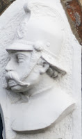
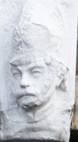
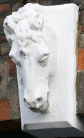
 The two plaques were easy to find, one being a plaque for Hull College which has had a presence in Park Street since 1898 and one being for a Volunteer Fire Brigade. The fire station had some carvings around the doorways that were good to see. The building is in reasonable condition and the carvings looked recently painted, to the extent that the layers of paint may be obscuring some of the detail in the carvings. The carvings were of firemen and horses. Apparently the firemen were the captains of the brigade at the time.
The carvings of horses showed they were as important to the brigade as their captains; horse-drawn engines being all that was available in 1887.
Worth a journey out in the snow.
The area close to the railway station in Hull has been rebuilt over recent years. Did I say railway station? I meant the Paragon Interchange of course. It used to be the Paragon station with the bus station next door, now they are all under one roof. Next door is a shopping centre called St Stephens. Not, you'll notice, the St Stephens commodity-cash interchange, but maybe that is coming. The roads to the west were changed or even removed as part of the process. St Stephens Square disappeared but gave its name to the shopping centre. The Spring Street theatre, which had the Hull Truck Theatre Company based there, has been replaced by a new theatre called the Hull Truck, presumably because it is not on Spring Street any more.
 A short new road was added to give access to an area otherwise cut off by the development. This is called Milky Way. Far from being a galactic super highway, it is where Northern Dairies had a distribution depot before the redevelopment.


 The two plaques were easy to find, one being a plaque for Hull College which has had a presence in Park Street since 1898 and one being for a Volunteer Fire Brigade. The fire station had some carvings around the doorways that were good to see. The building is in reasonable condition and the carvings looked recently painted, to the extent that the layers of paint may be obscuring some of the detail in the carvings. The carvings were of firemen and horses. Apparently the firemen were the captains of the brigade at the time.
The carvings of horses showed they were as important to the brigade as their captains; horse-drawn engines being all that was available in 1887.
Worth a journey out in the snow.
Subscribe to:
Comments (Atom)