I've just had a bit of surprise. I read an article about photographing the police becoming a criminal offence under certain circumstances. Read it here.
So, if I wander around a town or village making a map for OSM and I photograph a police officer, quite possibly by mistake, he or she could then start asking questions about what is going on. If I don't satisfy the officer I could then be arrested and my equipment confiscated. Simply by being arrested a sample of my DNA would then be stored on the police DNA database. I would not have to be found guilty or even charged to have my DNA taken, I just have to be arrested.
Now, I don't have anything to hide, I have a clear conscience, but I also know something about IT. I know that the database and the infrastructure around it is the weak link in this process. If my personal details and my DNA data get mixed up in the inner workings of some software upgrade, I could then get a knock on my door in the middle of the night- now imagine sorting that out and proving that the DNA database is wrong.
Now I know people will say there's a lot of 'ifs' here, and there are, but the fact that there are any 'ifs' at all is what is wrong. We need government security databases like we need more holes in our heads. We do need to remove erosion of our liberty because some paranoid control-freak in government thinks it might help with their re-election to the gravy-train by spinning some tale about protecting people from terrorism.
I'll get back to some mapping later this week, maybe we'll leave the eastern part of our county for a while and head west to Howden, I'll just keep the cops out of my viewfinder.
Tuesday, 26 May 2009


Thursday, 21 May 2009
Photo archives

I have been checking out the Holderness loop of the National Byway. I realised that I had seen part of the loop near Sunk Island. I checked the history of the roads I added there. That gave me the date it was added, so I turned to the CDs with my OSM photo archive for that date and dug out that day's photos. From the photos of the Holderness Loop signs I put together the missing route from Otteringham to Patrington.
Now we need to join up to the route near Tunstall and the pick up beyond the washed-away road at the coast and find how it rejoins the main Byway route.
Wednesday, 20 May 2009
Washed away
We've been working away at the southern end of Holderness again, last Sunday we looked at Winestead, Rimswell and Tunstall; today we reached Patrington, Holmpton and Out Newton. Sunday's run was mostly along small country roads - the villages are very small and simple to map. To start today's session we looked at Patrington. We added a bit of Patrington months ago when we visited Sunk Island. We've been though it many times on the way to Spurn Point, the sandy spit that sticks out into the mouth of the Humber, which is a pretty special nature reserve. Patrington is a set of small, twisty roads that were soon completed. We then set off for Holmpton.
 Holmpton was a pretty place with rolling little hedge lined lanes, but in spite of the drop in house prices there were quite a few houses for sale in such a small place. A trip along Seaside Road shows you why - the villages is being washed away into the North Sea. Tunstall is suffering the same fate. Part of the road that the National Byway Holderness Loop is on has washed away; the cycle route has been diverted.
We then headed along a little road to Out Newton which is a small, spread out place on the way towards Easington. We have yet to map Easington which has a huge gas terminal on the outskirts of the village. The gas terminal receives most of the gas from the North Sea rigs and also from a new pipeline from Norway to supplement our own dwindling supplies. The police have permanent armed patrols at the gas terminal to deter attacks from the omnipotent terrorist, so driving around taking photos might not go down well.
We need to find a way to trace the new coastline. Walking the cliffs is dangerous and much of it is private property. Walking the beach is difficult because the high tide reaches the foot of the cliffs, which is why the soft boulder clay washes away. The cliffs are receding by many metres each year where they are allowed to, so the aerial photos are already out-of-date. The existing coastal defences are being abandoned except at big or important places like Withernsea or Easington.
 Holmpton was a pretty place with rolling little hedge lined lanes, but in spite of the drop in house prices there were quite a few houses for sale in such a small place. A trip along Seaside Road shows you why - the villages is being washed away into the North Sea. Tunstall is suffering the same fate. Part of the road that the National Byway Holderness Loop is on has washed away; the cycle route has been diverted.
We then headed along a little road to Out Newton which is a small, spread out place on the way towards Easington. We have yet to map Easington which has a huge gas terminal on the outskirts of the village. The gas terminal receives most of the gas from the North Sea rigs and also from a new pipeline from Norway to supplement our own dwindling supplies. The police have permanent armed patrols at the gas terminal to deter attacks from the omnipotent terrorist, so driving around taking photos might not go down well.
We need to find a way to trace the new coastline. Walking the cliffs is dangerous and much of it is private property. Walking the beach is difficult because the high tide reaches the foot of the cliffs, which is why the soft boulder clay washes away. The cliffs are receding by many metres each year where they are allowed to, so the aerial photos are already out-of-date. The existing coastal defences are being abandoned except at big or important places like Withernsea or Easington.
Saturday, 16 May 2009
Up-to-date?
I didn't get out to gather any map data today, maybe tomorrow. I have been looking at the stuff we mapped last week. The Osmarender view is nicely up-to-date, but the Mapnik view (which I prefer) is not. Under the old scheme I knew that I would have to wait until the next weekly render and when that ran the whole area would be refreshed. Now the Mapnik view is supposed to refresh more quickly, but in practice this just means I don't know when it will refresh, it can take more than a week, and some zoom levels are sometimes missed altogether for a small area; it rarely updates in less than a couple of days.
I know that the upheaval of the upgrade to API 0.6 has caused a lot of extra work and some things might not be working fully yet, so I guess things will get better but it is very off putting when your work doesn't appear. A new mapper near me, who has had some problems understanding how things work, has hacked his editings back and forth believing that the reason his work has not appeared is that he has done something wrong. He has made some mistakes - he hasn't joined roads together, he left gaps in streams where they go under bridges and he has used the wrong tags - all things a newbie might be expected to do, but it doesn't help that he can't see his work and I can't tell him when it will appear.
Maybe what is needed is a way to request that a Mapnik tile-set be refreshed, just like Information Freeway can request an Osmarender refresh, in fact why not use this to trigger both views to be updated?
I know that the upheaval of the upgrade to API 0.6 has caused a lot of extra work and some things might not be working fully yet, so I guess things will get better but it is very off putting when your work doesn't appear. A new mapper near me, who has had some problems understanding how things work, has hacked his editings back and forth believing that the reason his work has not appeared is that he has done something wrong. He has made some mistakes - he hasn't joined roads together, he left gaps in streams where they go under bridges and he has used the wrong tags - all things a newbie might be expected to do, but it doesn't help that he can't see his work and I can't tell him when it will appear.
Maybe what is needed is a way to request that a Mapnik tile-set be refreshed, just like Information Freeway can request an Osmarender refresh, in fact why not use this to trigger both views to be updated?
Thursday, 14 May 2009
Robin path
 We are working towards completing the road network and the villages in the East Riding. We went to complete another couple of villages in Holderness, Burton Pidsea and Roos. They were both straight-forward. There was a residential road still being built without a name, but otherwise things went quite well. There are a number of footpaths, none of which we traced - we'll save that for another time, but one seemed to have a fan.
We also saw another section of the National Byway Holderness loop. This is beginning to make some sense now, but I'm not sure how the loop will join back to the main route. It would be easier to follow if it appeared on the cycle map (hint, hint).
Monday, 11 May 2009
Back to the river
 We had another wander along the banks of the river Hull. This time the section of river bank was closer to the city centre so I didn't expect it to be quite a green and open as the first section we walked. Part of the route was bounded by industrial areas, but there were open and pleasant areas too. Overall the walk was very pleasant and interesting. There were no butterflies around today - it was a bit cool and much too windy for them I think. We did see and hear plenty of birds. We heard more reed warblers in some reed beds and we saw a common sandpiper and a white throat. We also saw a bed of very fragrant flowers on the river bank that we are still trying identify (any clues anyone?) .
 We've seen a big wind turbine from all over the city, but today we walked very close to it. The photo doesn't really give the scale of the thing, but the works in the foreground are huge, yet they're dwarfed by the turbine. The wind was fairly strong, so the blades were whipping round with a deep whoosh. We found a little fishing pond nearby which I didn't know about and we had a look at the fairly large recreation ground next to it. I think I'll take a better look at this sometime later.
Thursday, 7 May 2009
River Hull
We've been out gathering data again. It felt like a pleasant walk along a river bank but we were actually gathering data. That's how OpenStreetMap works, some people get on with gathering data, some people use the data in exciting and creative ways, some people put in hours to manage the infrastructure and support software and a few people think of ways to short cut the process by importing data from other sources, some good, some not good and some would infringe other people's copyright if they were not stopped. Fortunately most people get the way it works and do the leg work to make a wonderfully complete map, which, by the way, is free for anyone to use.
 Today's data gathering was a walk along both banks of the river Hull between Sutton Road and Raich Carter Way. It turned out to be a very pleasant walk which for some of the time was hard to believe we were in a city at all. As we set off we passed a sunny glade between some bushes in in less than a minute we saw many butterflies including an orange tip, a comma and a green-veined white. They all flew off before I could photograph them. I've had lots of practice photographing butterflies and a sunny, breezy day makes it hard. There was, however, a speckled wood which did sit still long enough for me to snap its image. I think it felt safe against its background.
We then wandered along the path on top of the embankment at the west side of the river. There were swallows in the air and from the reed beds alongside the river we could hear the calls of reed warblers. When we reached the bridge at Raich Carter Way the traffic seemed deafening. We returned down the other bank, quickly getting back to the quiet and leaving the traffic noise as a very distant hum. The path ran along side open space with hedges and bushes full of birds. I really enjoyed this stroll. I'm looking forward to another one along another part of the river.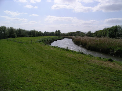
 Today's data gathering was a walk along both banks of the river Hull between Sutton Road and Raich Carter Way. It turned out to be a very pleasant walk which for some of the time was hard to believe we were in a city at all. As we set off we passed a sunny glade between some bushes in in less than a minute we saw many butterflies including an orange tip, a comma and a green-veined white. They all flew off before I could photograph them. I've had lots of practice photographing butterflies and a sunny, breezy day makes it hard. There was, however, a speckled wood which did sit still long enough for me to snap its image. I think it felt safe against its background.
We then wandered along the path on top of the embankment at the west side of the river. There were swallows in the air and from the reed beds alongside the river we could hear the calls of reed warblers. When we reached the bridge at Raich Carter Way the traffic seemed deafening. We returned down the other bank, quickly getting back to the quiet and leaving the traffic noise as a very distant hum. The path ran along side open space with hedges and bushes full of birds. I really enjoyed this stroll. I'm looking forward to another one along another part of the river.

Subscribe to:
Posts (Atom)